
Author's posts
Permits to Drill March 3, 2017
Dewey County REDINGER #1-12, March 01 2017 12 19N 17W E2E2W2NE API: 04322513 Lat: 36.140704979606895, Long: -98.96037942400689 OVERFLOW ENERGY LLC SH, RE, 9200 ft, BROWN DOLOMITE(3325), CHASE(4326), COUNCIL GROVE(4480), ADMIRE(4674), WABAUNSEE(5073), SHAWNEE(5210) Garvin County MCNEILL #1-35-2H, March 02 2017 26 2N 2W SESESESW API: 04925110 Lat: 34.60910257387943, Long: -97.37992527907873 RIMROCK RESOURCE OPERATING LLC HH, …
USGS Issues Potential Earthquake Hazards Map Forecast for 2017
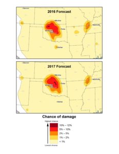
New maps identify potential ground-shaking hazards in 2017 from both human-induced and natural earthquakes in the central United States, according to information released on Wednesday by the U.S. Geological Survey. It marks the second year that induced seismicity is included on the earthquake hazard map. Approximately 3.5 million people live and work in areas with …
McClendon to Receive Posthumous Industry Legend Award from OIPA
The Oklahoma Independent Petroleum Association will honor the late Aubrey McClendon with its inaugural “OIPA Legend of the Industry” award during the association’s Wildcatters Gala set for March 21 at the Skirvin Hilton in Oklahoma City. Often recognized as a major player in America’s energy renaissance, the Oklahoma City oil executive reached the pinnacle of …
WTI, Brent Drop on Wednesday as Crude Oil Inventories Rise to New Weekly Record
Oil prices finished with a nominal drop on Wednesday as U.S. government data revealed an eighth weekly climb in a row for crude stockpiles, according to Bloomberg MarketWatch. April West Texas Intermediate crude fell 18 cents, or 0.3%, to settle at $53.83 a barrel on the New York Mercantile Exchange. May Brent crude, the global benchmark, …
Completion Reports March 2, 2017
MURRAY COUNTY Richardson Morris A Dba Fairview Production Co Oil Creek(1490): Oil 10 Pump 24 1N 2E Nw Sulphur Oil Creek Unit 14, February 20, 2017 SH, OIL, TD: 1504 ft Lat: 34.54465, Long: -97.05422 API: 35099206650000 PITTSBURG COUNTY Bp America Production Company Woodford: Gas 2500 Flow 34 6N 13E Hunt-garrett 3-34/3h, July 11, …
Permits March 2, 2017
Blaine County COBRA 30_19-17N-10W #1HX, March 01 2017 31 17N 10W NENWNWNE API: 01123753 Lat: 35.91247436902144, Long: -98.3062093987966 DEVON ENERGY PRODUCTION CO LP HH, DR, 20168 ft, MISSISSIPPIAN(8668), WOODFORD(10086) Blaine County SLO-POKE #1-33H, March 01 2017 33 18N 12W S2S2SWSE API: 01123754 Lat: 35.985768612479056, Long: -98.48298353730466 CARRERA ENERGY LLC HH, DR, 14424 ft, MISSISSIPPIAN(9790) …
Trump Signs Executive Order for Clean Water Act Rule Review
President Donald Trump signed an executive order on Tuesday directing the Environmental Protection Agency and U.S. Army Corps of Engineers to review a controversial 2015 Clean Water Act rule designed to protect small bodies of water from pollution, according to The Washington Times. “EPA’s so-called Waters of the U.S. rule is one of the worst …
Crude Oil Futures Post Monthly Gain, Slight Daily Drop on Tuesday
Oil futures fell slightly on Tuesday, but saw monthly gains for February as traders anxiously awaited data that may confirm a rise in domestic crude inventories for an eighth week in a row, according to Bloomberg MarketWatch. On the New York Mercantile Exchange, April West Texas Intermediate crude fell by 4 cents, or less …
Completion Reports March 1, 2017
CARTER COUNTY B & W Operating Llc Woodford- Sycamore: Oil 40 Gas 163 Water 150 Pump 18 2S 3W B&w Rose 1-18, December 12, 2016 SH, OIL, TD: 7090 ft Lat: 34.37772, Long: -97.56076 API: 35019255520002 CREEK COUNTY Liberty Operating Inc 19 15N 9E Sholmire 19-2, June 09, 2016 SH, DRY, TD: 2770 ft …
Permits to Drill March 1, 2017
Blaine County JANICE #1H-2623X, February 28 2017 26 16N 13W SESESWSE API: 01123750 Lat: 35.827338302031514, Long: -98.54793586670831 CIMAREX ENERGY CO HH, DR, 21512 ft, MISSISSIPPIAN(10204), WOODFORD(12000) Blaine County IGUANA 11-17N-10W #1H, February 28 2017 14 17N 10W NENENENW API: 01123751 Lat: 35.9560899423984, Long: -98.23752711144301 DEVON ENERGY PRODUCTION CO LP HH, DR, 14292 ft, MISSISSIPPIAN(8129), …