
Author's posts
Permits to Drill May 24, 2017
Beaver County BEASLEY #1-32, May 22 2017 32 6N 24E CNESE API: 00725153 Lat: 36.941423642083144, Long: -100.47927732544046 MARLIN OIL CORPORATION SH, RC, 6940 ft, CHEROKEE(5742) Blaine County DUNN #1R-15H, May 23 2017 22 16N 13W NWNWNWNE API: 01123806 Lat: 35.85495075083358, Long: -98.56909430727981 HIGHMARK ENERGY OPERATING LLC HH, DR, 16547 ft, MISSISSIPPIAN(11170), WOODFORD(11780), HUNTON(11875) Canadian …
Energy Trucks Parked at State Capitol to Remind Legislators of Recovering Industry
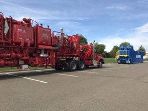
Name recognition comes easy for one of the world’s largest oil field services companies like Halliburton. It becomes more visible and apparent to state leaders when there are two large service trucks parked on the Oklahoma Capitol surface lot as the legislative session winds down. In a story published on Monday in The Oklahoman, reporter …
Crude Oil Futures Rise on Monday With OPEC Expected to Extend Production Agreement
Crude oil prices continued to climb on Monday as expectations grow for an extension to the OPEC production agreement, according to Bloomberg MarketWatch. With the June contract expiring at the session’s end, West Texas Intermediate crude added 40 cents, or 0.8%, to settle at $50.73 a barrel on the New York Mercantile Exchange. July WTI ended …
Completion Reports May 23, 2017
BLAINE COUNTY Carrera Energy Llc Mississippian: Oil 213 Gas 1696 Water 2499 Flow 22 18N 12W Butterfinger 22-1h, February 28, 2017 HH, OIL, TD: 14093 ft Lat: 36.02793, Long: -98.47541 API: 35011236880000 GARVIN COUNTY Citizen Energy Ii Llc Hunton: Oil 58 Gas 692 Water 282 Gas Lift 14 4N 4W Nayro 3h-11, February 17, …
Permits to Drill May 23, 2017
Alfalfa County BAKER 2512 #1-28 SWD, December 01 2016 28 25N 12W SWSWSESE API: 00323264 Lat: 36.609254422333485, Long: -98.49091367892261 MIDSTATES PETROLEUM COMPANY LLC SH, DR, 7205 ft, PERMIAN 3494 6(MISSISSIPPIAN), ENDICOTT(4578), TONKAWA(4903), COTTAGE GROVE(5331), OSWEGO(5684), HUNTON(6801), WILCOX(7155) Alfalfa County HARVESTER 11-25-12 #1H, May 22 2017 11 25N 12W NENENENW API: 00323278 Lat: 36.666169221457004, Long: …
WTI and Brent Crude Surge Over $50 a Barrel on Friday
Crude oil futures made an abrupt departure from losses, breaking the $50 a barrel benchmark and reaching their highest levels in a month, according to Bloomberg MarketWatch. June West Texas Intermediate crude added 98 cents, or 2%, to settle at $50.33 a barrel on the New York Mercantile Exchange. The settlement was the highest in over …
Permits to Drill May 22, 2017
Blaine County RED LAND #1-35H, May 19 2017 35 17N 10W SESESWSW API: 01123804 Lat: 35.899279364450564, Long: -98.24158282146381 PRIDE ENERGY COMPANY HH, DR, 14685 ft, MERAMEC(9462) Custer County HAMAR #3H-17, May 19 2017 20 14N 14W SENENENW API: 03922503 Lat: 35.6806723349386, Long: -98.71292073467048 EXCALIBUR RESOURCES LLC HH, DR, 16500 ft, RED FORK(11100) Ellis County …
Completion Reports May 22, 2017
BLAINE COUNTY Council Oak Resources Llc Mississippian(10134): Oil 297 Gas 7176 Water 1920 Flow 4 17N 13W Lau 1-4h, March 16, 2017 HH, GAS, TD: 15508 ft Lat: 35.97190, Long: -98.59976 API: 35011236650000 CANADIAN COUNTY Marathon Oil Company Mississippi Solid: Oil 606 Gas 4191 Water 1355 Flow 24 14N 9W Janice 1-24h, March 24, …
Crude Oil Futures Rise Higher on Thursday
Crude oil futures settled slightly higher on Thursday despite data suggesting that supply inventories are shrinking at a snail’s pace, according to Bloomberg MarketWatch. On the New York Mercantile Exchange, June West Texas Intermediate crude finished up 28 cents, or 0.6%, to settle at $49.35 a barrel. Brent crude, the global benchmark, added 30 cents, …
Completion Reports May 19, 2017
DEWEY COUNTY Mewbourne Oil Company Cleveland(9042): Oil 110 Gas 158 Water 2045 Flow 16 17N 19W Dean 9 Nc 1hc, April 23, 2017 HH, OIL, TD: 14050 ft Lat: 35.95618, Long: -99.23436 API: 35043234240001 GRADY COUNTY Continental Resources Inc Springer(12328): Oil 1808 Gas 2952 Water 1449 Flow 11 6N 6W Trammell 1r-11-14-23xh, February 10, …