
Author's posts
Permits to Drill October 18, 2017
Beaver County PHEASANT RUN #1-23, October 16 2017 23 6N 21E CN2NWSW API: 00723076 Lat: 36.971002838495494, Long: -100.7632556349357 HUNTINGTON ENERGY LLC SH, RC, 6380 ft, MORROW LOW(6010) Blaine County MARNITA FIU #1-3-34XHM, October 16 2017 03 13N 13W SESESESW API: 01123869 Lat: 35.624706009744344, Long: -98.57063316185213 CONTINENTAL RESOURCES INC HH, DR, 23932 ft, MISSISSIPPIAN(13828), WOODFORD(14660) Canadian County …
Worker’s Death Shuts Down Covington Solar Plant Jobsite in Garfield County
A Garfield County jobsite was shut down Monday morning after the death of a contractor, according to a news report by KWTV-9. The incident occurred around 10:00 a.m. when the worker became pinned underneath a trenching machine. The site is located near Longhorn Trail and Highway 74. The 10-megawatt solar photovoltaic power plant at Moss …
Bryan County Propane Tank Explosion Injures Three, Levels Home
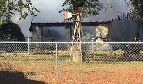
Three people were injured in a fiery home explosion in Bryan County on Monday morning, according to a news report by KWTV-9. The residence exploded about 8:30 a.m. in Mead, a southern Oklahoma community located about seven miles west of Durant. Bryan County investigators suspect that ignition of a propane tank is the cause …
WTI, Brent Crude Rise on Monday as Tensions Mount in the Middle East
Oil prices settled higher on Monday as increased tensions in the Middle East raised concerns over global crude supplies, according to Bloomberg MarketWatch. November West Texas Intermediate crude climbed by 42 cents, or 0.8%, to settle at $51.87 a barrel on the New York Mercantile Exchange. December Brent crude, the global benchmark, gained 65 cents, or …
Completion Reports October 17, 2017
CANADIAN COUNTY Newfield Exploration Mid-con Inc Woodford(9149): Oil 401.47 Gas 1440 Water 297 Flow 2 13N 7W Jennifer 1h-35x, November 16, 2016 HH, OIL, TD: 19378 ft Lat: 35.62486, Long: -97.90621 API: 35017249280001 DEWEY COUNTY Tapstone Energy Llc Mississippian(9215): Oil 153 Gas 3055 Water 1288 Flow / Gas Lift 24 19N 17W Amanda 13-19-17 1h, June 21, 2017 HH, GAS, TD: 16089 ft Lat: 36.11487, …
Permits to Drill October 17, 2017
Canadian County DORIS 12-13-10-6 #1XH, November 21 2016 01 10N 6W NWSESESE API: 01724948 Lat: 35.36424894718027, Long: -97.77970938832571 LINN OPERATING LLC HH, AM, 19539 ft, MISSISSIPPIAN(9361), WOODFORD(9567) Grady County TRIPLE H #5-30-31HS, October 16 2017 30 7N 5W NWNWNENE API: 05124208 Lat: 35.057771125572955, Long: -97.76251865734562 CONTINENTAL RESOURCES INC HH, DR, 21665 ft, GODDARD(11509) Grady County TRIPLE …
Crude Oil Futures Finish Strong on Friday
Crude oil futures jumped on Friday as traders weighed the outcome of President Trump’s decision to decertify the Iran nuclear agreement, according to Bloomberg MarketWatch. November West Texas Intermediate crude rose 85 cents, or 1.7%, to settle at $51.45 a barrel on the New York Mercantile Exchange. For the week, WTI was up around 4.4%. December …
Stephens County Natural Gas Leak Compels Evacuation Early Saturday

Stephens County residents returned to their homes following an evacuation early Saturday morning caused by a natural gas well leak, according to a news report by KWTV-9. On Saturday, Velma Fire Chief Jay Dumas indicated that a buildup of pressure caused the well head to release a vapor cloud of toxic hydrogen sulfide gas into …
Completion Reports October 16, 2017
ALFALFA COUNTY Midstates Petroleum Co Llc Mississippian: Oil 373 Gas 960 Water 3935 Pump 12 24N 12W Rebecca 2412 1h-13 A, August 25, 2017 HH, OIL, TD: 12393 ft Lat: 36.56511, Long: -98.43315 API: 35003232770000 Midstates Petroleum Co Llc Mississippian: Oil 90 Gas 118 Water 2755 Pump 12 24N 12W Rebecca 2412 1h-12 B, August 27, 2017 HH, OIL, TD: 12143 ft Lat: 36.56511, Long: …
Permits to Drill October 16, 2017
Blaine County HORNET 16_9-14N-12W #1HX, October 13 2017 21 14N 12W NWNENENE API: 01123868 Lat: 35.680926355565646, Long: -98.47423846680697 DEVON ENERGY PRODUCTION CO LP HH, DR, 23306 ft, MISS’AN LM(12501), WOODFORD(13311) Garvin County COLWELL #1-31-30H, October 13 2017 31 2N 2W SESWSWSW API: 04925161 Lat: 34.594726379801834, Long: -97.45621138152516 RIMROCK RESOURCE OPERATING LLC HH, DR, 15600 ft, WOODFORD(9200) …