
The latest Baker Hughes rig report showed the rig activity in Oklahoma remained at 32, unchanged from a week ago while the nationwide count increased by 6, reaching a total of 503 rigs. The U.S. count included 7 more oil rigs to reach a total of 401 while the number of gas rigs declined …
September 2021 archive
Natural gas-fired power burn sets June record
Natural gas-fired power generation across all sectors averaged 5.0 million megawatthours (MWh) per day in June 2021, 4% higher than the previous average June record set in 2020 reported the U.S. Energy Information Administration’s Electric Power Monthly. Despite daily natural gas spot prices at the Henry Hub averaging $3.26 per million British thermal units (MMBtu)—twice as …
Oil rallied on tight U.S. supplies but the rally didn’t help Oklahoma energy stocks
The growing signs of crude oil supply tightness as a result of Hurricane Ida in the U.S. caused oil prices to reach nearly $73 a barrel on Friday. West Texas Intermediate crude rose 2.3% or $1.58 to finish the day at $69.72 a barrel. Global benchmark Brent crude made the same 2.3% gain on …
Completion reports for September 10, 2021
CANADIAN COUNTY Red Bluff Resources Operating Llc Mississippian (less Chester): Oil 167 Gas 292 Water 2052 Flow 19 14N 5W Every 1405 4-30mh, March 03, 2021 HH, OIL, TD: 13450 ft Lat: 35.66791, Long: -97.77966 API: 35017255790001 KINGFISHER COUNTY Bce-mach Iii Llc Mississippian (less Chester)(6466): Oil 377 Gas 821 Water 623 Flow 34 18N 5W Rigdon 34-18-5 1h, May 21, 2021 HH, OIL, TD: 11730 ft …
Permits to drill for September 10, 2021
Canadian County EVERY 1405 #1-19MH, September 10 2021 19 14N 5W SWSWSWSW API: 01725705 Lat: 35.66791409624189, Long: -97.7795633938188 RED BLUFF RESOURCES OPERATING LLC HH, DR, 12633 ft, MISSISSIPPIAN (LESS CHESTER)(7600) Coal County FREELAND #2H-18, September 10 2021 12 1N 9E NESWSESE API: 02921410 Lat: 34.5653445889336, Long: -96.30438386219451 PABLO ENERGY II LLC HH, DR, 13200 ft, WOODFORD(7005) Kingfisher …
Maverick wind farm now serving PSO customers
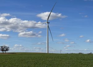
The second of three new wind facilities serving Public Service Company of Oklahoma (PSO) customers has begun commercial operation. Located southwest of Enid, the 287-megawatt (MW) Maverick facility is part of the 1,485-MW North Central Energy Facilities (NCEF) project. “PSO customers expect clean, renewable energy to be a growing part of our energy portfolio, …
What “Old Farmer’s Almanac” predicts this winter
If you’re a line repairman or work on oil and gas rigs in Oklahoma, the Old Farmer’s Almanac suggests it will probably be another tough winter in 2021 and 2022. The 230-year old publication claims its predictions are 80% accurate and this year, its annual forecast says the upcoming winter will be the “season …
Why Missouri’s largest wind farm is idle at night
The deaths of bats at the site of Missouri’s largest wind farm caused the owner to idle the operation so it wouldn’t kill more endangered and threatened bats. Now the move is playing a role in the company’s request to increase customers’ rates reported the Kansas City Star. Click here for Kansas City Star
Completion reports for September 9, 2021
CARTER COUNTY Butkin Oil Company Llc 25 2S 3W Brooks 8, August 19, 2021 SH, INJ, TD: 3335 ft Lat: 34.36057, Long: -97.46075 API: 35019081520002 KINGFISHER COUNTY Cottonmouth Swd Llc 24 18N 9W Mojave Swd 1, July 15, 2021 null, SVC, TD: 12043 ft Lat: 36.01851, Long: -98.12059 API: 35073263590000 Ovintiv Mid-continent Inc. Mississippian(8030): Oil 1287 Gas 2758 Water 1985 Flow 27 …
Permits to drill for September 9, 2021
Coal County LDC ##24/25-3H, August 13 2021 13 2N 9E NWSWNWSE API: 02921405 Lat: 34.641393939587395, Long: -96.30985545347279 CANYON CREEK ENERGY ARKOMA LLC MU, AM, 15500 ft, WOODFORD(6500) Coal County DON #2H-13, September 09 2021 12 1N 9E NESWSESE API: 02921409 Lat: 34.56533634505051, Long: -96.3044336831877 PABLO ENERGY II LLC HH, DR, 13200 ft, WOODFORD(6500) Garvin County BELITA CASEY …