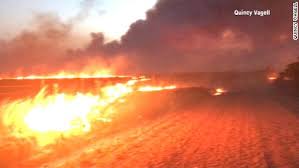
While there are no existing burn bans in Oklahoma as of this week, windy conditions on Wednesday presented potentially dangerous situations for wild fires.
The Oklahoma Department of Agriculture, Food and Forestry Services stated that the highest danger of wildfires existed in the western half of the Panhandle although the possibility of thunderstorms might have offset the threat.
Temperatures in the Panhandle were expected near 80 degrees and afternoon relative humidity values were expected to drop as low as 23 percent. Wind gusts of 30 mph were also in the forecast.
With warmer and windier conditions for the state, there was the increased potential in north-central and parts of northeastern Oklahoma where moderate rates of fire spread were expected.
The Forestry Fire Situation report indicated if there are wildfires in the northeast, the strong winds will create some fast-moving fires with flames average 13 to 18 feet in length.
Fire dangers are expected to be elevated on Thursday as temperatures will approach 80 degrees and there will be light winds. Dry conditions are also expected to grow.
However, the Forestry department indicated that critical fire danger indices are expected to be west of the Oklahoma and Texas state line.

