
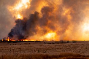
As western Oklahoma becomes dryer because of a more than month-long lack of rain, state firefighters are being warned they could face wildfires with 20-foot flames and speeds of 170 feet a minute, if they do break out.
It’s the warning from the Oklahoma Forestry Services in a Thursday wildfire update. It noted that as the much-touted warming trend kicked off Thursday with temperatures well into the 90s, it will only add fuel to any wildfires that occur.
“The well above-normal temperatures will continue through Saturday ahead of a cold front that will spike fire danger concern Sunday,” stated the Forestry Services. It noted grassland has become dryer in areas north of I-44.
“Resistance to control has increased in recent days requiring additional firefighting resources during initial attack and longer resource commitment to fully contain wildfires.”
The state agency warned that hot and dry conditions coupled with breezy south winds on Saturday will “drive elevating fire behavior potential supporting an uptick in initial attack activity as well as increasing large fire probabilities.”
The dangers will increase on Sunday when a dry cold front hits the state.
Calling the front a “well-known bad actor regarding fire danger,” the Forestry experts believe Sunday could offer even greater dangers.
“Large fire potential increases dramatically on Sunday as winds intensify shifting from south to north becoming gusty with the frontal boundary.”
Their advisory said because of the drying conditions, “some fires eclipsing the 5,000 acre mark (especially west) cannot be ignored.”