


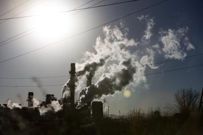
A textbook example of environmental racism. It’s how the Sierra Club describes power plants in Denver, Colorado.
In a new report, the environmental group said that for decades, low-income communities of color in Denver were “disproportionately burdened by pollution from multiple sources, including highways that cut through neighborhoods, oil refineries and power plants that burn coal and gas.”
(Read the full report here)
The report labeled Xcel Energy’s Cherokee and Arapahoe gas plants as “textbook examples of environmental racism since they are located in the two areas of Denver with majority Hispanic/Latino populations.” The Sierra Club claimed that every year the plants spew dangerous air pollutants into surrounding neighborhoods that have a higher percentage of people of color than most of Colorado, a lower median household income and higher overall health burdens compared to the Denver metro area.
The club’s report claimed:
1. Xcel’s Denver gas plants are major polluters and a serious harm to human health.
Nitrogen oxide (NOx), Sulfur dioxide (SO2), and Carbon dioxide (CO2) are the primary air pollutants emitted by gas-fired power plants like Cherokee and Arapahoe.
2. Xcel Energy’s gas plants are located in low-income communities of color with higher-than-average health burdens and rates of COVID-19.
Xcel Energy’s gas plants are both located in areas of Denver where the population is predominantly Hispanic/Latino. People of color account for 71 percent of the population within three miles of the Cherokee gas plant, and 45 percent for the population within three miles of the Arapahoe gas plant.


Communities adjacent to the Cherokee and Arapahoe gas plants also suffer from more health problems than the rest of the Denver metro area.

3. Xcel Energy’s gas plants are located in parts of Denver that are already disproportionately affected by many combined sources of localized pollution, and by climate change.
The Environmental Protection Agency’s EJScreen tracks 11 different environmental indicators that help to measure the presence of compounding localized pollution sources on a population. In the three-mile area surrounding the Cherokee gas plants, nine of those 11 indicators are at or above the 84th percentile statewide.

The neighborhoods adjacent to the Cherokee and Arapahoe gas plants have the highest heat vulnerability scores,
Source: Sierra Club