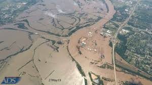
The spread of the flooding over northern and eastern Oklahoma is hard to imagine, unless you see ‘before’ and ‘after’ pictures.
News on 6 in Tulsa showed the scale of the flooding as indicated in pictures taken by Aerial Data Service Inc. Pictures taken by the company were from 8,000 feet.
Aerial Data Service, Inc. is located in Tulsa, Oklahoma and provides aerial photography and mapping services to hundreds of engineering firms and governmental agencies across the country.
Click here to see KOTV’s story with pictures.