


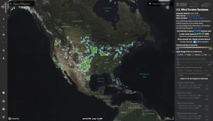
A new map has been released displaying wind farm development across the U.S. The U.S. Wind Turbine Database is a continuously updated data portal of U.S. wind turbine locations and characteristics.
Wind farms across Oklahoma, Texas and other states are easily displayed as a result of the map developed through a partnership of the U.S. Geological Survey, American Wind Energy Association and Lawerence Berkely National Laboratory and the Department of Energy.
The dataset reveals the turbine height, rotor diameter, capacity and year online for wind farms throughout Oklahoma. The number of “clicks” on the USWTDB surpassed 1 million in September.
Click here to see the wind farm map.
Click here for the wind turbine data site offering detailed information about Oklahoma wind farms and others.