


A state beside Oklahoma is getting earthquake attention in relation to its extensive oil and gas drilling activity.
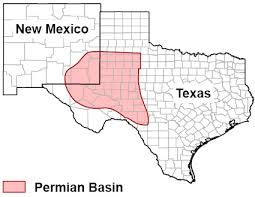
Stanford University has decided that the massive Permian Basin and its high-level of drilling activity should be mapped for “ground stresses” and possible earthquakes. They continue working on a map for Oklahoma but have come out with one for Texas.
While Oklahoma has been the focus of numerous university studies and reports from the U.S. Geological Survey because of the state’s quakes, Texas is now getting attention.
Scientists at Stanford are studying the 75,000 square mile for the potential of quakes there. They want to know if the significant increase in drilling activity will cause a spike in quakes in west Texas and southeast New Mexico.
The scientists have released a color-coded map as part of their research which was published in the journal “The Leading Edge” from the Society of Exploration Geophysicists.
One of the co-authors of the study, Mark Zoback told Science Daily it’s simple “We want to get out ahead of the problem in Texas.”
He is the Benjamin M. Page Professor of Geophysics at Stanford’s School of Earth, Energy and Environmental Sciences.
“We want to stop fluid injection from triggering even small earthquakes in Texas earthquakes so that the probability of larger earthquakes is significantly reduced.”
The new maps were based in part on previous maps of faultlines and stress potential in the Permian. But the scientists added new data and it offers a different picture of the ground stresses in the basin.
Some contend the Permian has the potential for increased earthquake activity simply because of the need for wastewater injection wells in connection with increased oil and gas drilling. Also, because of the different variations in rock and soil in the region.